top of page
3D Topographical Maps, 3D Topography, 3D GIS, India 3D map, 3D survey, 3D terrain maps, 3D GIS mapping, 3D mapping company, 3D aerial photogrammetry, 3D terrain, 3D mapping, 3D topography, Topographic Mapping Services, Topo Survey, Topographic Survey, Topographical Survey, Topographical Survey near me, Topographical surveyor, Topo Mapping, Terrain Mapping, Topo Survey India, Digital Elevation Model, digital elevation mapping, digital elevation model GIS, digital elevation models, dem model, dem india, Digital Terrain Model, Digital Surface Model, Topography analysis, Photogrammetry Surveying, Photogrammetry, Digital Photogrammetry Services, Stereo Compilation, Orthophoto Production, Aerial Triangulation, Geospatial Imagery, Photogrammetry Services, Photogrammetry Companies in India, Land Surveying, Land Surveys, Drone Image Processing, Drone LiDAR Surveying, Aerial Photography in India, Aerial Survey Companies in India, Digital Land Surveying and Mapping, Topographical Survey,

3D City Topographical Maps
with Mobile and
Aerial LiDAR

Navigating Urban Lanscapes With our 3D topographical Maps

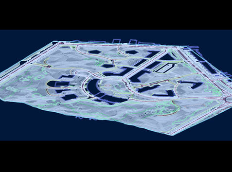
SISL specializes in utilizing your LiDAR data to produce highly detailed 3D topographical maps, offering invaluable insights into urban landscapes. With state-of-the-art geospatial technology and a team of skilled professionals, we deliver precise and comprehensive representations of terrains and assets.

Urban Planning: Optimize city development strategies with a detailed understanding of the terrain and infrastructure.


Emergency Response: Enhance emergency preparedness by having accurate asset information readily available for quick response and recovery.
Infrastructure Management: 
Streamline maintenance and upgrade planning with comprehensive asset mapping.


Environmental Monitoring: Monitor changes in vegetation, land cover, and geological features for sustainable urban development.

3D Topographical Maps, 3D Topography, 3D GIS, India 3D map, 3D survey, 3D terrain maps, 3D GIS mapping, 3D mapping company, 3D aerial photogrammetry, 3D terrain, 3D mapping, 3D topography, Topographic Mapping Services, Topo Survey, Topographic Survey, Topographical Survey, Topographical Survey near me, Topographical surveyor, Topo Mapping, Terrain Mapping, Topo Survey India, Digital Elevation Model, digital elevation mapping, digital elevation model GIS, digital elevation models, dem model, dem india, Digital Terrain Model, Digital Surface Model, Topography analysis, Photogrammetry Surveying, Photogrammetry, Digital Photogrammetry Services, Stereo Compilation, Orthophoto Production, Aerial Triangulation, Geospatial Imagery, Photogrammetry Services, Photogrammetry Companies in India, Land Surveying, Land Surveys, Drone Image Processing, Drone LiDAR Surveying, Aerial Photography in India, Aerial Survey Companies in India, Digital Land Surveying and Mapping, Topographical Survey,

Topographical Features

Elevation Changes:
Accurate depiction of variations in ground elevation, providing crucial information for urban planning and flood risk assessment.
Contours:

Visualization of contour lines to represent the shape and slope of the land.
Landforms:

Identification of natural landforms, including hills, valleys, plateaus, and ridges.
Surface Roughness:

Mapping the variations in surface roughness, aiding in infrastructure planning and development.
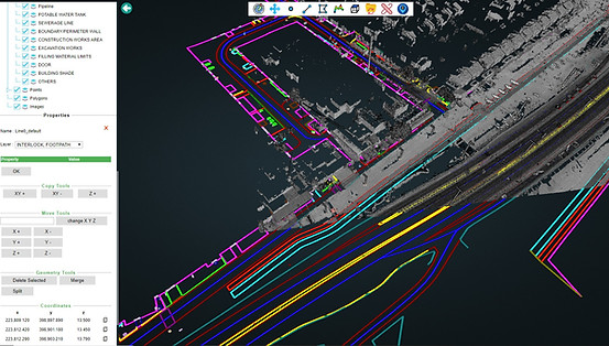
Urban Features

Buildings and Structures:
Detailed representation of architectural structures within the cityscape.
Vegetation and Land Cover:

Identification and categorization of vegetation types, including trees, shrubs, and green spaces.
Utilities and Infrastructure:

Accurate mapping of utility lines, such as power lines, water pipes, and telecommunication cables.
Transportation Networks:

Thorough mapping of roads, curbs, markings, highways, bridges etc.
Street Furniture:

Urban elements like streetlights, traffic signs/lights, benches, cycle stands, bollards, dustbins, etc.
Geological Features:

Representation of natural terrain features, including hills, slopes, retaining walls, 
Water Bodies: 

Mapping of rivers, lakes, ponds, culverts, ditches, etc.
Land Use Classification:

Categorization of land areas based on their use, such as residential, commercial, industrial, and agricultural zones.

Mobile Mapping

Related Projects

LIDAR data processing, processing LIDAR data, topo survey, topographical survey, digital elevation model, photogrammetry surveying, terrain mapping, mobile mapping, digital mapping, land surveying, GIS company in India, GIS services, GIS consulting, GIS consultant, GIS service, land surveying company, survey company India, survey company in India, land surveyors company, land survey company, DEM model, geospatial companies, land survey services, geotechnical company in India, planimetric mapping, planimetric maps, land surveyor in India, remote sensing image processing, image processing remote sensing, geotechnical company, infrastructure mapping, laser mapping, utility mapping, utilities mapping, digital land surveying and mapping, DEM India, GIS mapping services, mobile LIDAR, LIDAR for forestry, LIDAR India, LIDAR companies, telecom GIS, LIDAR classification, multispectral camera for agriculture, drone LIDAR surveying, utility mapping in GIS, GIS services company, LIDAR services
Lidar Classification

Highway, cities Assets/Features extraction from more than 60,000 KM of road network.

Yearly Road Conditioning and Asset Capturing

Mobile Mapping on geo-ref. videos
3D Topographical Maps, 3D Topography, 3D GIS, India 3D map, 3D survey, 3D terrain maps, 3D GIS mapping, 3D mapping company, 3D aerial photogrammetry, 3D terrain, 3D mapping, 3D topography, Topographic Mapping Services, Topo Survey, Topographic Survey, Topographical Survey, Topographical Survey near me, Topographical surveyor, Topo Mapping, Terrain Mapping, Topo Survey India, Digital Elevation Model, digital elevation mapping, digital elevation model GIS, digital elevation models, dem model, dem india, Digital Terrain Model, Digital Surface Model, Topography analysis, Photogrammetry Surveying, Photogrammetry, Digital Photogrammetry Services, Stereo Compilation, Orthophoto Production, Aerial Triangulation, Geospatial Imagery, Photogrammetry Services, Photogrammetry Companies in India, Land Surveying, Land Surveys, Drone Image Processing, Drone LiDAR Surveying, Aerial Photography in India, Aerial Survey Companies in India, Digital Land Surveying and Mapping, Topographical Survey,
3D Mapping

The project area of 1200 linear kms, to be completed within 4 months. A team of 30 Mobile Mapping experts working round the clock to ensure delivery of accurate, uniform and complete data. Project estimated more than 25,000 man hours.

3D Topographic Map on MLS Data 

MLS Mapping

Contact

A-13, Damodar Colony,
Garh Road, Meerut, 250004
India

+91 9837008018

2D & 3D Planimetric, 3D Mapping, 2D GIS Mapping, Planimetric Mapping, Planimetric Maps, Aerial LiDAR Survey, Aerial Survey, Aerial Survey Companies, Aerial Mapping Companies, Aerial Mapping Services, Aero Triangulation, 2D Drafting Services, Aerial Photogrammetry Services, Aerial Imaging Services, LiDAR Maps, Drone surveying company, UAV surveying companies, Drone survey in India, Aerial Photography in India, Drone Image Processing, Drone LiDAR Surveying, Aerial Triangulation, Photogrammetry, Photogrammetry Surveying, Photogrammetry Services, Photogrammetry Companies in India, Digital Photogrammetry Services, Orthophoto Production, Stereo Compilation, Digital Elevation Models, Digital Mapping, Mapping Services, Map Services, GIS Mapping Services, Land Surveying Services, Land Survey in India, Land Survey Company, Land Surveyors Company, Digital Land Surveying and Mapping, Remote Sensing Image Processing, Topo Mapping, Topo Survey, Digital Mapping Solutions, GIS Mapping, GIS Consulting
  • Sai Infotech Systems, SISL, GIS Services, GIS consultant, GIS consultants, GIS company in India,
  • GIS solutions, GIS mapping services, GIS mapping companies in India, GIS data conversion,
  • GIS information services, GIS for telecom, GIS for telecommunications, GIS based mapping,

Copyright : 2006:2025. Sai Infotech Systems Ltd. All Rights Reserved

bottom of page